Hand Working in D&S IFCA’s District
Page review/updated 04/12/2024
(Content of overview page last updated: 31st March 2022)
CRAB TILE SURVEYS
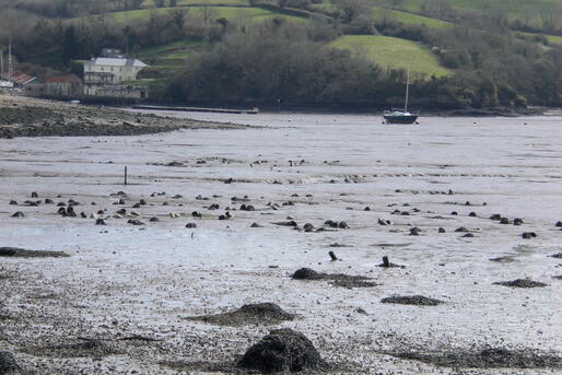
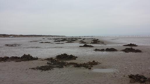
Crab tiling is a method of collecting shore crab (Carcinus maenas) for the use as a prized fishing bait by sea anglers. Like other crustaceans, shore crabs moult their shells at intervals during their life cycle, during which they seek refuge from predators. Crab tilers exploit this behaviour, providing artificial shelters such as roof tiles, guttering, drainpipes, chimney pots and tyres. Whilst sheltering under tiles, the crabs are either peeling or in the ‘soft shell’ state. It is in this state that the crabs may be collected for fishing bait during low tide when the tiles are exposed. The ‘soft shell’ state crab tends to be full of water so fishers will try and collect crabs that are in the pre- moulting or during moulting stage before the hard shell is discarded. In this condition it is a ‘peeler crab’ and is a more effective bait as it is full of natural body juices. This method of bait collection has been used throughout Devon for generations.
Every four years, surveys are carried out to determine the number and location of crab tiles on the estuaries in the D&S IFCA’s District. These surveys were taken on by D&S IFCA in 2012. Previously a survey was carried out in 2003 by the Devon Biodiversity Records Centre for all Devon estuaries, and one was carried out on the Exe by the Exe Estuary Management Partnership in 2008. These surveys gave the IFCA a baseline level of crab tiling effort.
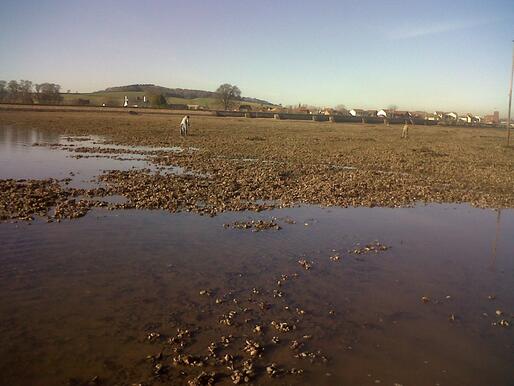
The surveys enable D&S IFCA to assess the potential impacts of crab tiling on sensitive estuary environments, and to inform the development of appropriate management. Surveys are traditionally undertaken on foot in challenging, muddy conditions, often in remote and hard to reach locations. Some areas are easier to find using a small tin boat. Counts are made by getting as close to the tiles as possible but at times are estimated with the use of binoculars. A GPS is used to map the location of the tiles, although on occasion this has to be estimated. Surveys were carried out by D&S IFCA in 2012 for the Exe Estuary and the Tamar Estuaries, the full reports for these can be found here for the Exe Estuary and here for the Tamar.
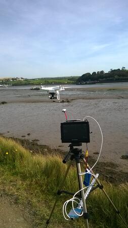
In 2015 the Environment Team experimented with a novel way to survey crab tiles using an Unmanned Aerial Vehicle (UAV), or drone as they are commonly referred to. This help reduced the amount of time taken to undertake the surveys and were demanding in terms of the number of officers needed to undertake the surveys. The drone surveys also recorded more accurate tile positions in the more potentially dangerous locations. The UAV company, Vertical Horizons Media, were commissioned to carry out a trial survey on the Taw Torridge Estuary.
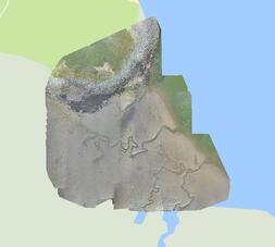
The trial was carried out at low water on spring tides to get the best coverage. Maps from past surveys were supplied to the UAV operator who created a flight plan to cover the full extent of areas which may have tiles. The UAV then flew this path, recording the GPS track, and taking photos every few seconds. The images were processed to create geo-tiles, which are images with a GPS location attached. These can then be overlaid onto Google Earth and by zooming in the tiles can be counted and their exact location marked.
As this was a new survey method for D&S IFCA and the UAV operator, IFCA officers spent a day on the Taw Torridge Estuary to ground truth a small area to ensure the images and locations matched up with the traditional method of surveying crab tiles by foot.
The ground truthing showed accurate mapping and the trial was deemed to be a success. Geolocated images allowed for exact positional data and estimated numbers of crab tiles to be determined without stepping foot on the estuary. The full report for this trial can be found here.
The UAV was used to undertake the survey on the Exe in 2016 as this is the biggest site for crab tiles in the District. The other smaller estuaries and sites were surveyed using the traditional method – by foot and boat. The 2016 survey report can be read here.
In 2020, the UAV methodology was adopted for all the estuaries, apart from the Axe due to the small numbers of tiles found in 2016. The 2020 survey report can be found here.
BAIT DIGGING SURVEYS
Digging for polychaete worms to use as bait for sea anglers occurs throughout many of the D&S IFCA’s District’s estuaries and shores. The two main species targeted are blow lugworm (Arenicola marina) and king ragworm (Alitta virens). Bait digging is carried out using forks to dig holes or trenches for the target species on the intertidal mud and sandflats.
The activity takes place in several Marine Protected Areas (MPAs) in the District including the Severn Estuary SAC and SPA, Plymouth Sound & Estuaries SAC, Tamar Estuaries SPA and MCZ, Exe Estuary SPA and the Torbay MCZ. It is the IFCA’s responsibility to assess whether bait digging will impact the habitats and birds within these sites.
To assess any significant impact of bait digging on the MPAs’ features, Habitat Regulation Assessments and Marine Conservation Zones Assessments were undertaken. However, before these could be completed, more research was needed to understand the level of bait digging both recreationally and commercially within the MPAs.
Surveys have been carried out in the in the MPAs mentioned above since 2012, with at least one year’s worth of data being collected for each site. Surveys were planned in a semi-stratified way to get even coverage of spring and neap tides, weekends, and weekdays. Surveys took place over the low tide period, starting two hours before low water and finishing two hours after.
Details of the weather conditions, time, tidal state, number of bait diggers present, number of holes or trenches observed, and GIS co-ordinates of the areas dug were recorded for each trip. Interviews were conducted on surveys where bait digging was observed, and when it was safe to do so. Interviews provided additional information on bait digging behaviour, effort, and perceptions. Results have been analysed and reports have been complied for Severn Estuary EMS, Exe Estuary EMS, Plymouth Sound EMS & Tamar MCZ, and the Torbay MCZ.
D&S IFCA is currently undertaking an assessment of bait digging activity in the following estuaries that have been designated as Marine Conservation Zones (MCZ) in the third tranche of designations; Otter, Axe (Lyme Bay), Erme, Devon Avon, and the Dart. Officers are gathering information and evidence to better understand locations of bait digging, levels of activity, and what is important to stakeholders in these areas.
HAND GATHERING SURVEYS
Surveys were carried out at the Exe Estuary EMS and Torbay MCZ to assess the levels of hand gathering. Hand gathering is the collection of sea resources from the intertidal areas within the District. These may include, but not limited to, mussels, cockles and other molluscs, crabs and lobsters from gullies and rock pools, and seaweed. These are picked by hand, raked, or hooked depending on the species being collected.
In the Torbay MCZ, the surveys were carried out alongside the bait digging surveys. The surveys were carried out at six sites within the MCZ in 2016 and 2017 with a total of 54 surveys being carried out. Information was gathered on location, number, species, and amount collected where possible. A report was compiled and the results fed into the MCZ assessment for the site. The information has also fed into the hand working management process which is ongoing.
In 2016 a total of 16 hand gathering surveys were carried out at eight locations on the Exe Estuary, four on the west shore and four on the east shore. The main areas for shellfish collection were found to be at Cockwood and Cockle Sands, with mussels, cockles and winkles being targeted. A brief summary report was compiled and the results fed into the Habitat Regulation Assessment for the site and will feed into the development of any hand working management.